Next Previous Up Contents
Next: Multiple Positional Search Panel
Up: Common Features
Previous: Registry Query Panel
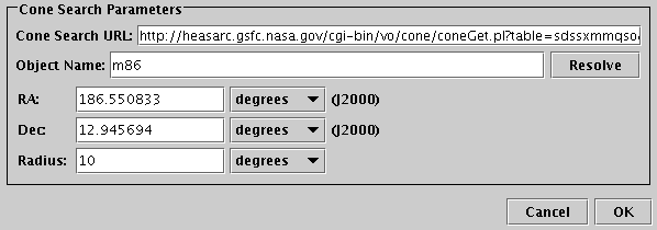
Single Positional Search Panel
The Single Positional Search Panel appears in VO-based table load dialogues
and is used to specify data queries on a single region of the sky.
The purpose is to load a new table
(containing entries representing catalogue entries, images or spectra).
To use it you must fill in the URL field and
the position definition, and then hit the OK button.
-
URL
- This must contain the service URL for the data service that you
are querying. Usually, this will be filled in by selecting one
of the services obtained by the
registry query.
However, you can fill it in manually with the URL of a service you
know about if you prefer. If you know what you're doing,
it's also possible to doctor a service URL
filled in by the registry selection, for instance by adding
&name=value parameters to it.
-
Object Name
- You can fill this in with the name of an object to be resolved
by SIMBAD, and hit the Resolve button, which will
fill in the coordinates in the RA and Dec fields below.
If you enter the RA and Dec manually, you don't need to use this field.
-
RA and Dec
- Fill in the central position in terms of J2000 Right Ascension
and Declination that you are interested in here.
You can either do it manually, or by using the Object Name
field as above.
Select the units as appropriate.
-
Radius
- Indicates how large is the region you are interested in.
This field has slightly different appearance and meaning for the different
data service types; hover over it with the mouse to see a tooltip with
the details. For SIA and SSA, but not for Cone Search, it is permissible
to leave it blank (though certain services don't seem to like that).
Select the units as appropriate.
When the fields are filled in, hit the OK button and
wait for the new table defined by your query parameters to load.
If you get bored waiting (the service may be down, or just very slow, or you
may have submitted a query with a very large return set),
you can hit the Cancel button,
and perhaps adjust the parameters and try again.
If a SAMP hub is running (see Section 9),
then other running clients may be able to fill in the RA and Dec
coordinates. For instance clicking on a sky position in an image
viewing tool might fill in the sky position you clicked on.
Usually this will happen automatically.
This is often convenient, but may not be what you want.
You can control whether incoming coordinate settings are accepted in this way
using the Accept Sky Positions toggle below the
Resolve button, or using the corresponding item in the
Interop menu.
Next Previous Up Contents
Next: Multiple Positional Search Panel
Up: Common Features
Previous: Registry Query Panel
TOPCAT - Tool for OPerations on Catalogues And Tables
Starlink User Note253
TOPCAT web page:
http://www.starlink.ac.uk/topcat/
Author email:
m.b.taylor@bristol.ac.uk
Mailing list:
topcat-user@jiscmail.ac.uk